
The Global Precipitation Measurement mission or GPM core observatory satellite probed super typhoon Trami when it traveled above the northwestern Pacific Ocean and provided an analysis of heavy rainfall and cloud top heights.
The Global Precipitation Measurement mission or GPM core observatory satellite probed super typhoon Trami when it traveled above the northwestern Pacific Ocean and provided an analysis of heavy rainfall and cloud top heights.
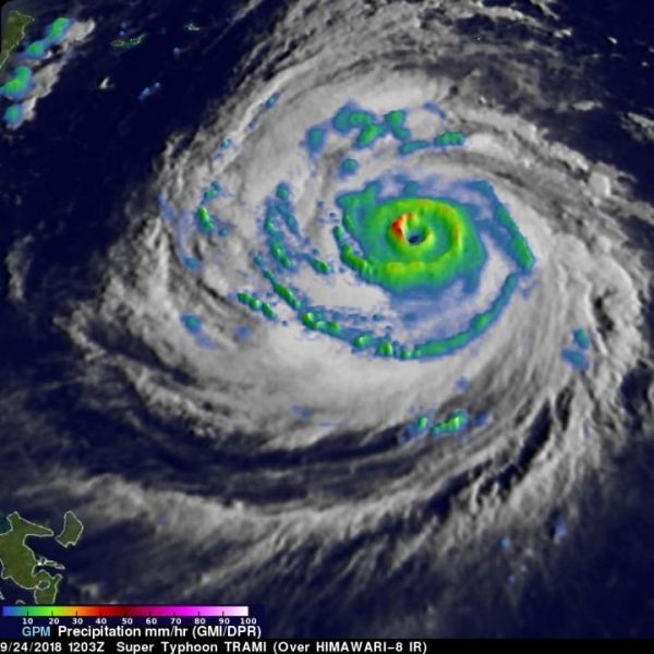
GPM, a joint satellite mission between NASA and the Japan Aerospace Exploration Agency, JAXA, flew over Trami on Sept. 24, 2018 at 8:03 a.m. EDT (1203 UTC). At that time Trami had maximum sustained winds estimated at 130 knots (150 mph). Rainfall measurements were made using data collected by GPM’s Microwave Imager (GMI) and Dual-Frequency Precipitation Radar (DPR) instruments. GPM’s GMI showed the locations of extremely heavy rainfall in the super typhoon’s well defined circular eye.
GPM’s radar (DPR Ku Band) coverage was limited because its swath only included storms on the western side of the typhoon. GPM’s DPR showed that rain was falling at a rate of over 120 mm (4.7 inches) per hour within intense storms in a strong feeder band well southwest of Trami’s eye.
Read more at NASA/Goddard Space Flight Center
Image: The GPM core satellite flew over Trami on Sept. 24, 2018, at 8:03 a.m. EDT (1203 UTC) and found extremely heavy rainfall in the super typhoon's well defined circular eye. Rain was also falling at a rate of over 120 mm (4.7 inches) per hour within intense storms in a strong feeder band well southwest of Trami's eye. (Credit: NASA/JAXA, Hal Pierce)


