
NASA’s Aqua satellite and NASA-NOAA’s Suomi NPP Satellite passed over the Florida Panhandle and captured different views of Hurricane Michael after it made landfall on Oct. 10. Hurricane Michael is the most powerful storm on record to hit the Florida Panhandle.
NASA’s Aqua satellite and NASA-NOAA’s Suomi NPP Satellite passed over the Florida Panhandle and captured different views of Hurricane Michael after it made landfall on Oct. 10. Hurricane Michael is the most powerful storm on record to hit the Florida Panhandle.
A Visible View of Michael
NASA-NOAA’s Suomi NPP satellite provided this visible image of Hurricane Michael after it made landfall in the Florida panhandle on Oct. 10. The image revealed high clouds over the eye, located in the panhandle. Michael’s extent covered Alabama, the western half of Georgia and the northern half of Florida.
Infrared View Shows Michael as a Powerful Rainmaker
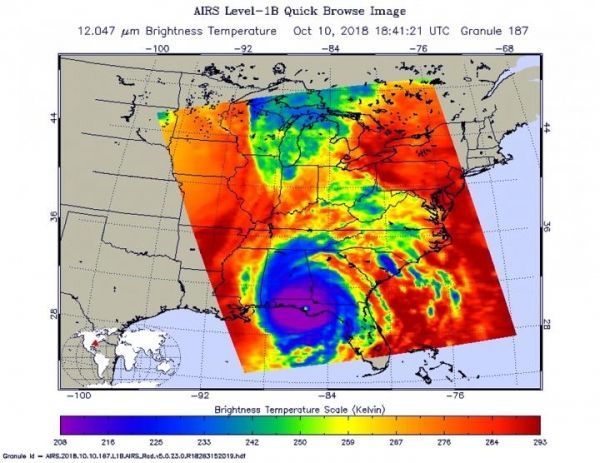
On Oct. 10 at 2:41 p.m. EDT (1841 UTC) the Atmospheric Infrared Sounder or AIRS instrument aboard NASA’s Aqua satellite provided an infrared view of Hurricane Michael after landfall. The AIRS image showed that Michael still maintained a clear eye, and was surrounded by a large symmetric area of powerful thunderstorms. Those powerful thunderstorms had cloud top temperatures near 208 kelvin (minus 85.2 degrees Fahrenheit/minus 65.1 degrees Celsius). NASA research has shown that cloud top temperatures that cold in storms indicate the storms have the capability to generate heavy rainfall.
Read more at NASA/Goddard Space Flight Center
Image: On Oct. 10 at 2:41 p.m. EDT (1841 UTC) the AIRS instrument aboard NASA's Aqua satellite provided an infrared view of Hurricane Michael after landfall. The AIRS image showed that Michael still maintained a clear eye, and was surrounded by a large symmetric area of powerful thunderstorms. (Credit: NASA JPL, Heidar Thrastarson)


