
NOAA’s Office of Coast Survey and the National Geodetic Survey (NGS) recently conducted operational tests of small unmanned aerial systems — or drones — on board NOAA Ship Thomas Jefferson in support of survey operations conducted along the south coast of Puerto Rico.
NOAA’s Office of Coast Survey and the National Geodetic Survey (NGS) recently conducted operational tests of small unmanned aerial systems — or drones — on board NOAA Ship Thomas Jefferson in support of survey operations conducted along the south coast of Puerto Rico. The tests show the potential of imagery from low-cost off-the-shelf drones to meet NOAA survey specifications for near-shore and shoreline feature mapping. This could replace traditional shoreline verification and mapping techniques used by NOAA hydrographic survey field units. Potential benefits of using drones for shoreline mapping include: improved data collection efficiency compared to data collection from small skiffs; more accurate feature investigation than traditional techniques; and, most importantly, removal of personnel from potentially dangerous situations (i.e. survey in close proximity to features being mapped).
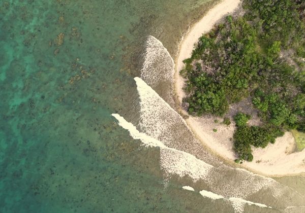
NOAA Ship Thomas Jefferson hosted Capt. Brian Taggart (NOAA, ret.) from NGS’s Remote Sensing Division (RSD) and Lt. j.g. Matt Sharr from Coast Survey’s Hydrographic Systems and Technology Branch (HSTB) while conducting survey operations in the vicinity of Ponce, Puerto Rico. The Ponce drone operations were a continuation of previous RSD and HSTB tests and training. The Ponce project area provided ideal testing grounds, including shallow water zones, dynamic and feature-rich shoreline environment, and clear tropical waters. The team mapped multiple test areas within the project area including Islas Caja De Muertos, Morrillito de Ratones (and associated reef), and Cayo Berberia.
So how do two-dimensional images collected from the drone become three-dimensional models for shoreline mapping? The process is called, “structure from motion.” Structure from motion processing techniques use sequences of overlapping geo-referenced imagery taken by the drone to create 3D geo-referenced models of environments. Simply put, it takes 2D pictures of features from different angles and then builds 3D models of the same features. Although the structure from motion technology may seem ‘black box’ (or unclear) since all computational work is accomplished with just a few button clicks, the technology itself is not as magic as it seems. Computations used to build 3D models from 2D imagery only require linear algebra, high resolution geo-referenced imagery, and a pivot-supported camera.
Continue reading at NOAA.
Image via NOAA.


