
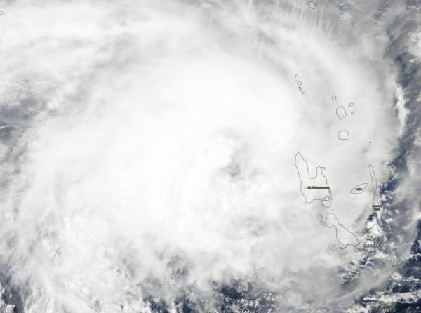
Visible imagery from NASA’s Aqua satellite revealed the center of Tropical Cyclone Oma was just northwest of the island of Vanuatu in the South Pacific Ocean.
Visible imagery from NASA’s Aqua satellite revealed the center of Tropical Cyclone Oma was just northwest of the island of Vanuatu in the South Pacific Ocean.
Vanuatu consists of roughly 80 islands that stretch about 808 miles (1,300 kilometers).
The Vanuatu Meteorology and Geo-Hazards Department (VMGD) issued Tropical Cyclone Warning Number 18 for the Torba, Sanma, Penama and Malampa Provinces. Those provinces can expect heavy rainfall and flash flooding over low lying areas and areas close to the river banks. In addition, coastal flooding will continue.
The Vanuatu National Disaster Management Office (NDMO) noted that a red alert remains in force for Torba, Sanma, Penama and Malampa provinces, while yellow alert is in effect for the Shefa province.
Read more at NASA/Goddard Space Flight Center
Image: On Feb. 14, 2019, the MODIS instrument aboard NASA's Aqua satellite captured a visible light image of Tropical Cyclone Oma in the Southern Pacific Ocean. Oma's center is northwest of Vanuatu. (Credit: NASA Worldview, Earth Observing System Data and Information System (EOSDIS))


