
Tropical Cyclone Veronica continued to move toward Australia’s Pilbara Coast in Western Australia.
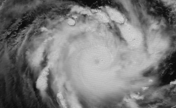
Tropical Cyclone Veronica continued to move toward Australia’s Pilbara Coast in Western Australia. NASA-NOAA’s Suomi NPP satellite provided visible and infrared images of the storm that indicated heavy rainfall.
The Australian Bureau of Meteorology, or ABM updated warnings on March 22. The Warning zone extends from Wallal Downs to Mardie including Port Hedland, Karratha and Barrow Island.
The Watch zone extends to the inland Pilbara to include Pannawonica, Marble Bar and Nullagine.
Suomi NPP passed over Savannah on March 22 and the Visible Infrared Imaging Radiometer Suite (VIIRS) instrument provided visible and infrared images of the storm. William Straka III, who created some of the images noted “As you would expect, the infrared channel on VIIRS showed large amounts of tropospheric gravity waves and overshooting [cloud] tops associated with the intense convection. In another image Veronica was illuminated by the full moon.”
Read more at NASA / Goddard Space Flight Center
Image: NASA-NOAA’s Suomi NPP satellite passed over the Southern Indian Ocean and captured a visible image of Severe Tropical Cyclone Veronica on March 22 as it moved toward the Pilbara Coast of Western Australia. Veronica was illuminated by the full moon. CREDIT: NASA/NOAA/UWM-CIMSS, William Straka III


