
NASA’s Aqua satellite used infrared light to analyze the strength of storms in the developing low pressure area designated as System 91L as it moved through the Gulf of Campeche just north of Mexico’s Yucatan Peninsula.
NASA’s Aqua satellite used infrared light to analyze the strength of storms in the developing low pressure area designated as System 91L as it moved through the Gulf of Campeche just north of Mexico’s Yucatan Peninsula.
Infrared data provides temperature information, and the strongest thunderstorms that reach high into the atmosphere have the coldest cloud top temperatures.
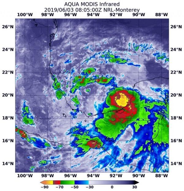
On June 3 at 4:05 a.m. EDT (0805 UTC), the Moderate Imaging Spectroradiometer or MODIS instrument that flies aboard NASA’s Aqua satellite gathered infrared data on developing System 91L. Strongest thunderstorms created a southern ring around the center from west to east, where cloud top temperatures were as cold as minus 80 degrees Fahrenheit (minus 62.2 Celsius). Cloud top temperatures that cold indicate strong storms with the potential to generate heavy rainfall. Those strongest storms were located just off the coast of the state of Campeche and the eastern part of the state of Tabasco.
Read more at NASA / Goddard Space Flight Center
Image: On June 3 at 4:05 a.m. EDT (0805 UTC), the MODIS instrument that flies aboard NASA’s Aqua satellite gathered infrared data on developing System 91L. Strongest thunderstorms (yellow) created a southern ring around the center from west to east, where cloud top temperatures were as cold as minus 80 degrees Fahrenheit (minus 62.2 Celsius). Credit: NASA/NRL


