
The efficient extraction of oil and gas from within the Earth’s crust requires accurate images of subsurface rock structures.
The efficient extraction of oil and gas from within the Earth’s crust requires accurate images of subsurface rock structures. Some materials are hard to capture, so KAUST researchers have developed a computational method for modeling large accumulations of subsurface salt, a challenging material to derive accurately from seismic imaging data.
Seismic imaging involves sending soundwaves into the ground, where they will be reflected at boundaries between rock structures. Scientists analyze the reflected soundwaves to determine subsurface rock types and formations, and to pinpoint fossil fuel reservoirs.
However, in some regions, such as the Gulf of Mexico, the subsurface is peppered with salt bodies, which are huge accumulations of salt formed millions of years ago deep inside the Earth. Salt is a low-density, buoyant substance, meaning that salt bodies gradually rise through the Earth’s crust over time. This causes stress-related complexities between the salt and the surrounding rock layers. Furthermore, the salt’s crystal structure means that soundwaves are reflected at random, and there are no useable low frequencies retained in the seismic data.
“Data from salt zones are presently analyzed by highly trained experts rather than modeled by a computer,” explains Mahesh Kalita, a KAUST Ph.D. student in Tariq Alkhalifah's group. “This is a time-consuming and expensive process that carries the risk of human error. We’ve developed a robust computational method for interpreting seismic data from salt bodies quickly and more accurately.”
Read more at King Abdullah University of Science & Technology (KAUST)
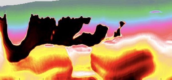
Image: The output of the proposed methodology, which is a two-part optimization process that refines a common technique used to image salt bodies. The black area represents the salt region. (Credit: © 2019 Mahesh Kalita)


