
Wind shear can push clouds and thunderstorms away from the center of a tropical cyclone and that’s exactly what infrared imagery from NASA’s Terra satellite shows is happening in newly formed Tropical Storm 07W.
Wind shear can push clouds and thunderstorms away from the center of a tropical cyclone and that’s exactly what infrared imagery from NASA’s Terra satellite shows is happening in newly formed Tropical Storm 07W.
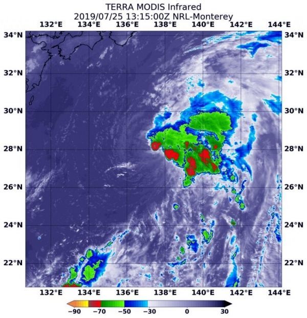
NASA’s Terra satellite used infrared light to analyze the strength of storms and found the bulk of them on the eastern side of the storm. Infrared data provides temperature information, and the strongest thunderstorms that reach high into the atmosphere have the coldest cloud top temperatures.
On July 25 at 9:15 a.m. EDT (1315 UTC), the Moderate Imaging Spectroradiometer or MODIS instrument that flies aboard Terra gathered infrared data on 07W and showed the strongest thunderstorms had cloud top temperatures as cold as minus 70 degrees Fahrenheit (minus 56.6 Celsius). Cloud top temperatures that cold indicate strong storms with the potential to generate heavy rainfall.
Read more at NASA / Goddard Space Flight Center
Image: On July 25 at 9:15 a.m. EDT (1315 UTC) the MODIS instrument that flies aboard NASA’s Terra satellite showed strongest storms in Tropical Storm 07W were east of the elongated center where cloud top temperatures were as cold as minus 70 degrees Fahrenheit (in red) (minus 56.6 Celsius). Credit: NASA/NRL


