
Infrared imagery from NASA’s Aqua satellite found just a small area of cold clouds in thunderstorms within weakening Tropical Depression Dalila, enough to maintain it as a tropical cyclone.
Infrared imagery from NASA’s Aqua satellite found just a small area of cold clouds in thunderstorms within weakening Tropical Depression Dalila, enough to maintain it as a tropical cyclone.
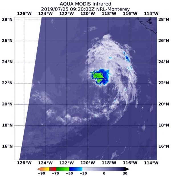
NASA’s Aqua satellite uses infrared light to analyze the strength of storms by providing temperature information about the system’s clouds. The strongest thunderstorms that reach high into the atmosphere have the coldest cloud top temperatures.
On July 25 at 5:20 a.m. EDT (0920 UTC), the Moderate Imaging Spectroradiometer or MODIS instrument that flies aboard NASA’s Aqua satellite gathered infrared data on Dalila. There was still a small area of strong thunderstorms with cloud top temperatures as cold as minus 50 degrees Fahrenheit (minus 45.5 Celsius). The National Hurricane Center or NHC noted, “Dalila is still technically a tropical cyclone based on the development of new convection within 70-75 nautical miles northeast of the center.” That thunderstorm development was enough to maintain its classification as a tropical cyclone.
Read more at NASA / Goddard Space Flight Center
Image: On July 25 at 5:20 a.m. EDT (0920 UTC), the MODIS instrument that flies aboard NASA’s Aqua satellite showed strongest storms in Dalila were in a small area north of the center. There cloud top temperatures were as cold as minus 50 degrees Fahrenheit (minus 45.5 Celsius). Credit: NASA/NRL


