
Hurricane Erick continued hold onto its status as it moved west through the Central Pacific.
Hurricane Erick continued hold onto its status as it moved west through the Central Pacific. NASA-NOAA’s Suomi NPP satellite passed overhead and found two small areas of very strong thunderstorms, showing Erick still had some punch left in it.
Fortunately, Erick is a small hurricane and the National Hurricane Center expects those winds to be 200 miles from Hawaii as it passes the islands.
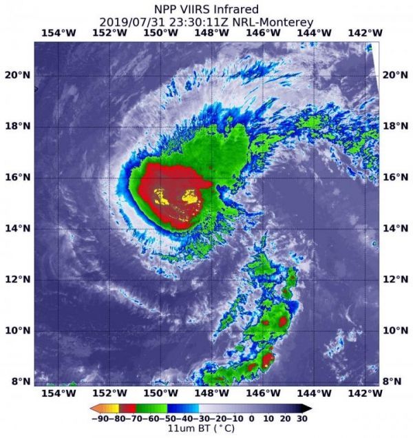
The Visible Infrared Imaging Radiometer Suite (VIIRS) instrument aboard Suomi NPP provided an infrared image of the storm. Infrared imagery reveals cloud top temperatures, and the higher the cloud top, the colder it is, and the stronger the storm. On July 31 at 7:30 p.m. EDT (2330 UTC). There were two small areas within where cloud top temperatures were as cold as minus 80 degrees Fahrenheit (minus 62.2 Celsius). Storms with cloud tops that cold have been found to generate heavy rainfall.
Read more at NASA/Goddard Space Flight Center
Image: NASA-NOAA's Suomi NPP satellite passed over Hurricane Erick in the Central Pacific Ocean and the VIIRS instrument aboard captured this image of the storm on July 31 at 7:30 p.m. EDT (1:30 p.m. HST/2330 UTC). There were two small areas (yellow) within where cloud top temperatures were as cold as minus 80 degrees Fahrenheit (minus 62.2 Celsius). (Credit: NASA/NRL)


