
Tropical Storm Flossie continues tracking in a westward direction through the Eastern Pacific Ocean and is expected to move into the Central Pacific Ocean later today, August 2.
Tropical Storm Flossie continues tracking in a westward direction through the Eastern Pacific Ocean and is expected to move into the Central Pacific Ocean later today, August 2.
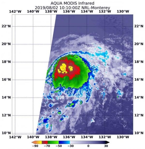
NASA’s Aqua satellite used infrared light to provide temperature information of clouds and sea surface. The strongest thunderstorms that reach high into the atmosphere have the coldest cloud top temperatures. Cloud top temperatures that cold indicate strong storms with the potential to generate heavy rainfall.
On August 2 at 6:10 a.m. EDT (1010 UTC), the Moderate Imaging Spectroradiometer or MODIS instrument that flies aboard NASA’s Aqua satellite found those strongest storms around the center and in fragmented bands of thunderstorms circling the center, where cloud top temperatures as cold as minus 80 degrees Fahrenheit (minus 62.2 Celsius).
Read more at NASA/Goddard Space Flight Center
Image: On August 2, 2019 at 6:10 a.m. EDT (1010 UTC) the MODIS instrument that flies aboard NASA's Aqua satellite showed strongest storms in Tropical Storm Flossie around the center and in fragmented bands of thunderstorms circling the center, where cloud top temperatures were as cold as minus 80 degrees Fahrenheit (minus 62.2 Celsius). (Credit: NASA/NRL)


