
Typhoon Krosa is a large storm moving through the Northwestern Pacific Ocean and infrared imagery from NASA’s Aqua satellite revealed that the large typhoon also has a large eye.
Typhoon Krosa is a large storm moving through the Northwestern Pacific Ocean and infrared imagery from NASA’s Aqua satellite revealed that the large typhoon also has a large eye.
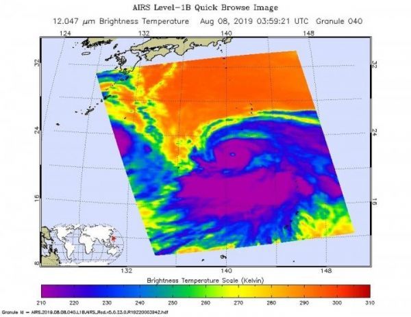
Cloud top temperatures provide information to forecasters about where the strongest storms are located within a tropical cyclone. NASA’s Aqua satellite took Typhoon Krosa’s cloud top temperatures to get that information. NASA’s Aqua satellite analyzed the storm on Aug. 7 at 11 p.m. EDT (0359 UTC) using the Atmospheric Infrared Sounder or AIRS instrument. The stronger the storms, the higher they extend into the troposphere, and they have the colder cloud temperatures. AIRS found coldest cloud top temperatures as cold as or colder than minus 63 degrees Fahrenheit (minus 53 degrees Celsius) around the eye and in large bands south and east of the center. Cloud top temperatures that cold indicate strong storms that have the capability to create heavy rain.
Early on Aug. 9, the Joint Typhoon Warning Center noted that infrared data revealed that Krosa has an eye that is 40 nautical-miles wide.
Read more at NASA/Goddard Space Flight Center
Image: On Aug. 7 at 11 p.m. EDT (0359 UTC) the AIRS instrument aboard NASA's Aqua satellite analyzed cloud top temperatures of Typhoon Krosa in infrared light. AIRS found coldest cloud top temperatures (purple) of strongest thunderstorms were as cold as or colder than minus 63 degrees Fahrenheit (minus 53 degrees Celsius). Krosa had a 40 nautical-mile-wide eye. (Credit: NASA JPL/Heidar Thrastarson)


