
Tiny Tropical Storm Henrietta is the newest addition to the tropical cyclone line-up in the Eastern Pacific Ocean. The storm developed early on Aug. 12 and soon after the GPM satellite passed overhead and found heavy rain happening around its center.
Tiny Tropical Storm Henrietta is the newest addition to the tropical cyclone line-up in the Eastern Pacific Ocean. The storm developed early on Aug. 12 and soon after the GPM satellite passed overhead and found heavy rain happening around its center.
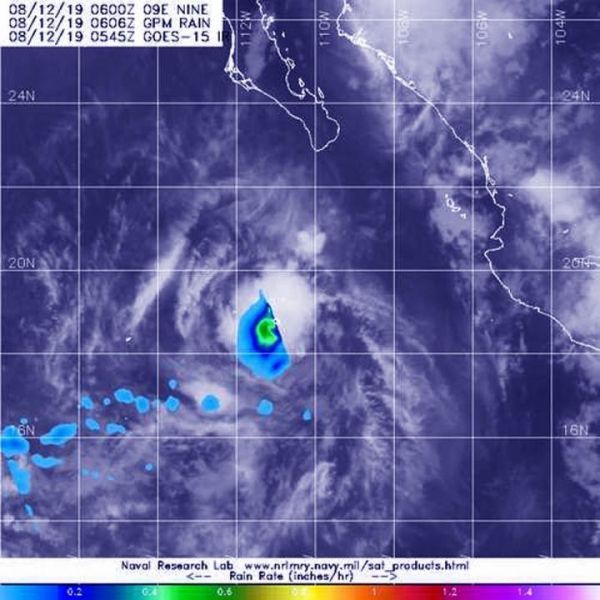
The Global Precipitation Measurement mission or GPM core satellite passed over Tropical Storm Henrietta at 2:06 a.m. EDT (0606 UTC) on August 12, 2019. GPM found the heaviest rainfall was around the center of circulation falling at a rate of 25 mm (about 1 inch) per hour, over open waters of the Eastern Pacific. GPM is a joint mission between NASA and the Japan Aerospace Exploration Agency, JAXA.
NOAA’s National Hurricane Center (NHC) said, at 11 a.m. EDT (1500 UTC), the center of Tropical Storm Henrietta was located near latitude 19.7 degrees north and longitude 112.2 degrees west. The storm is far enough away from land that there are no coastal warnings in effect. It is about 265 miles (430 km) southwest of the southern tip of Baja California, Mexico.
Read more at: NASA/Goddard Space Flight Center
The GPM core satellite passed over Tropical Storm Henrietta at 2:06 a.m. EDT (0606 UTC) on August 12, 2019. GPM found the heaviest rainfall (orange) around Henrietta's center of circulation falling at a rate of 25 mm (about 1 inch) per hour. (Photo Credit: NASA/JAXA/NRL)


