
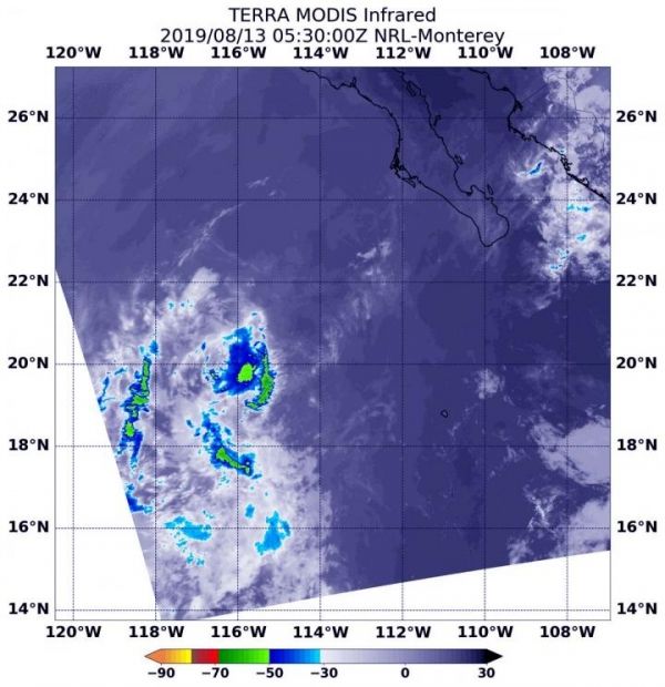
Infrared imagery from NASA’s Terra satellite found just a few scattered areas of cold clouds in the Eastern Pacific Ocean’s Tropical Depression Henriette on August 13.
Infrared imagery from NASA’s Terra satellite found just a few scattered areas of cold clouds in the Eastern Pacific Ocean’s Tropical Depression Henriette on August 13.
NASA’s Terra satellite uses infrared light to analyze the strength of storms by providing temperature information about the system’s clouds. The strongest thunderstorms that reach high into the atmosphere have the coldest cloud top temperatures.
On August 13 at 1:30 a.m. EDT (0530 UTC), the Moderate Imaging Spectroradiometer or MODIS instrument that flies aboard NASA’s Terra satellite gathered infrared data on Henriette.
MODIS found just a few scattered areas of cold clouds in thunderstorms in the depression. Those thunderstorms had cloud top temperatures as cold as minus 50 degrees Fahrenheit (minus 45.5 Celsius).
Read more at NASA/Goddard Space Flight Center
Image: On August 13, 2019 at 1:30 a.m. EDT (0530 UTC), the MODIS instrument that flies aboard NASA's Terra satellite showed strongest thunderstorms in Tropical Depression Henriette were fragmented. Coldest cloud top temperatures were as cold as minus 50 degrees Fahrenheit (minus 45.5 Celsius). (Credit: NASA/NRL)


