
NASA-NOAA’s Suomi NPP satellite passed over Tropical Storm Dorian as it triggered warnings and watches for the islands of the Eastern Caribbean Sea.
NASA-NOAA’s Suomi NPP satellite passed over Tropical Storm Dorian as it triggered warnings and watches for the islands of the Eastern Caribbean Sea.
On Monday, August 26, 2019, a Tropical Storm Warning is in effect for Barbados, Martinique, St. Lucia, St. Vincent and the Grenadines. A Tropical Storm Watch is in effect for Dominica, Grenada and its dependencies, Saba and St. Eustatius. A Hurricane Watch is in effect for St. Lucia.
Dorian formed as a tropical depression on Saturday, Aug. 24 about 805 miles (1,300 km) east-southeast of Barbados. By 5 p.m. EDT that day, the depression strengthened into a tropical storm and was named Dorian.
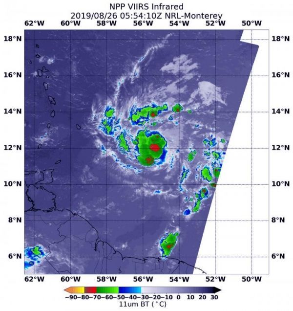
NASA-NOAA’s Suomi NPP satellite passed over Tropical Storm Dorian in the western North Atlantic Ocean on Aug. 26 at 1:54 a.m. EDT (0554 UTC). The Visible Infrared Imaging Radiometer Suite (VIIRS) instrument aboard Suomi NPP provided an infrared image of the storm. Infrared imagery reveals cloud top temperatures, and the higher the cloud top, the colder it is, and the stronger the storm. Coldest cloud top temperatures were as cold as minus 70 degrees Fahrenheit (minus 56.6 Celsius) and found around the center of circulation, southwest of the center and in fragmented bands of thunderstorms north of the center. Storms with cloud tops that cold have been found to generate heavy rainfall.
Read more at NASA/Goddard Space Flight Center
Image: NASA-NOAA's Suomi NPP satellite passed over Tropical Storm Dorian in the western North Atlantic Ocean and the VIIRS instrument aboard captured this image of the storm on Aug. 26 at 1:54 a.m. EDT (0554 UTC). Coldest (red) cloud top temperatures were as cold as minus 70 degrees Fahrenheit (minus 56.6 Celsius). (Credit: NASA/NRL)


