
Infrared imagery from NASA’s Terra satellite revealed Tropical Depression 13W contained some powerful thunderstorms pushing high into the troposphere as it was moving west in the Philippine Sea toward the Philippines.
Infrared imagery from NASA’s Terra satellite revealed Tropical Depression 13W contained some powerful thunderstorms pushing high into the troposphere as it was moving west in the Philippine Sea toward the Philippines.
Tropical Depression 13W has already triggered warnings in the Philippines because it is located just east of the country. Philippines warnings include Tropical cyclone wind signal #1 over the following Luzon provinces: Cagayan, Isabela, Quirino, Nueva Vizcaya, Apayao, Abra, Kalinga, Mountain Province, Ifugao, Benguet, Aurora, Nueva Ecija, eastern portion of Pangasinan, northern portion of Quezon including Polillo Island and Catanduanes.
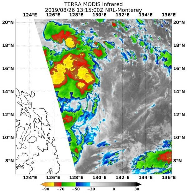
NASA’s Terra satellite used infrared light to analyze the strength of storms and found the most powerful thunderstorms stretching north over the center from west to east. Infrared data provides temperature information, and the strongest thunderstorms that reach high into the atmosphere have the coldest cloud top temperatures.
Read more at NASA / Goddard Space Flight Center
Image: On August 26 at 9:15 a.m. EDT (1315 UTC), the MODIS instrument that flies aboard NASA’s Terra satellite found strongest storms (yellow) had cloud top temperatures as cold as minus 80 degrees Fahrenheit (minus 62.2 Celsius). CREDIT: NASA / NRL


