
ASA’s Aqua satellite provided forecasters at the National Hurricane Center with visible imagery and infrared data on Tropical Storm Dorian as it continued its western track into the Eastern Caribbean Sea.
ASA’s Aqua satellite provided forecasters at the National Hurricane Center with visible imagery and infrared data on Tropical Storm Dorian as it continued its western track into the Eastern Caribbean Sea. Infrared data provided an indication of the storm’s heavy rain making potential.
On Wednesday, August 28, 2019, the National Hurricane Center or NHC noted that a Hurricane Watch is in effect for Puerto Rico, Vieques, Culebra, and the U.S. Virgin Islands. A Tropical Storm Warning is in effect for Puerto Rico, Vieques, Culebra, the U.S. Virgin Islands and the British Virgin Islands. A Tropical Storm Watch is in effect for the Dominican Republic from Isla Saona to Samana.
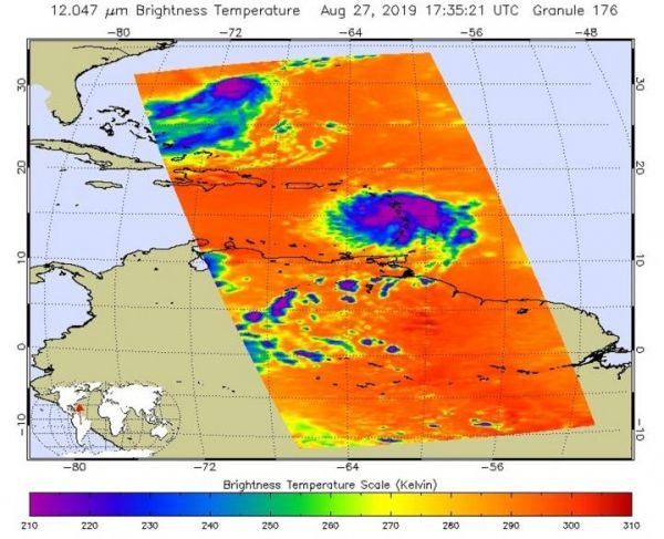
ACloud top temperatures provide information to forecasters about where the strongest storms are located within a tropical cyclone. The stronger the storms, the higher they extend into the troposphere, and the colder the cloudtop temperatures. NASA’s Aqua satellite analyzed Tropical Storm Dorian’s cloud tops to get that information. AIRS found that some areas in Dorian were being affected by dry air, which was sapping the development of thunderstorms.
Read more at: NASA/Goddard Space Flight Center
On Aug. 27, 2019 at 1:35 p.m. EDT (1735 UTC), the AIRS instrument aboard NASA's Aqua satellite analyzed cloud top temperatures of Tropical Storm Dorian in infrared light. AIRS found coldest cloud top temperatures (purple) of strongest thunderstorms were as cold as or colder than minus 63 degrees Fahrenheit (minus 53 degrees Celsius). (Photo Credit: NASA JPL/Heidar Thrastarson)


