
NASA’s Terra satellite passed over the northwestern Atlantic Ocean as Dorian reached hurricane status during the afternoon of August 28, 2019.
NASA’s Terra satellite passed over the northwestern Atlantic Ocean as Dorian reached hurricane status during the afternoon of August 28, 2019.
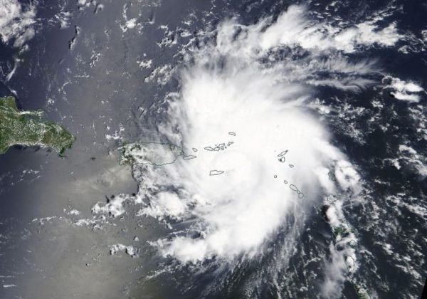
On Aug. 28, 2019 at 1:30 p.m. EDT, the Moderate Resolution Imaging Spectroradiometer or MODIS instrument aboard NASA’s Terra satellite provided a visible image of Dorian near St. Thomas and the U.S. Virgin Islands. At 2 p.m. EDT, the National Hurricane Center noted, “Satellite and radar images indicate that the cloud pattern has become better organized during the past several hours.”
Dorian strengthened over the warm waters of the eastern Caribbean Sea and was officially designated a Category 1 hurricane on the Saffir-Simpson Hurricane Wind Scale at 2 p.m. EDT.
At 2 p.m. EDT, a Hurricane Warning is in effect for Vieques and Culebra, the U.S. Virgin Islands and the British Virgin Islands. The National Hurricane Center issued a Tropical Storm Warning for Puerto Rico with a Hurricane Watch also in effect as changing conditions warrant.
Read more at NASA / Goddard Space Flight Center
Image: On Aug. 28, 2019 at 1:30 p.m. EDT, the MODIS instrument aboard NASA’s Terra satellite provided a visible image of Dorian as it became a hurricane near St. Thomas and the U.S. Virgin Islands. Credit: NASA Worldview, Earth Observing System Data and Information System (EOSDIS)


