
Hurricane Dorian is packing heavy rain as it moves toward the Bahamas as predicted by NOAA’s NHC or National Hurricane Center.
Hurricane Dorian is packing heavy rain as it moves toward the Bahamas as predicted by NOAA’s NHC or National Hurricane Center. NASA analyzed the storm and found heavy rainfall in the storm.
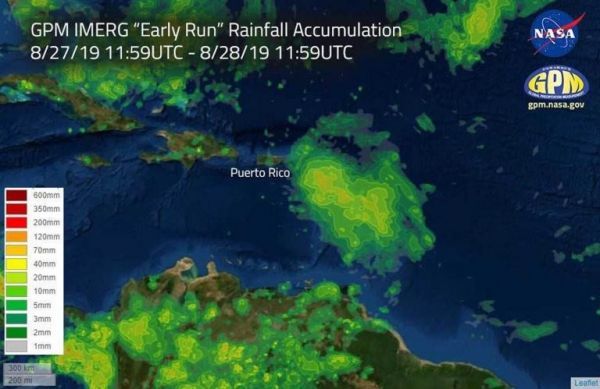
NASA has the ability to peer under the “hood” or clouds of a tropical cyclone and estimate the rainfall rates occurring. After looking into Dorian’s clouds, imagery was generated using the Integrated Multi-satEllite Retrievals for GPM or IMERG “early run” product, at NASA’s Goddard Space Flight Center in Greenbelt, Maryland. IMERG uses a constellation of satellites united by the GPM Core Observatory to provide global observations of Earth’s precipitation every 30 minutes.
IMERG estimated rainfall accumulations for the region affected by Hurricane Dorian over the 24 hour period of August 27 at (7:59 a.m. EDT) 11:59 UTC to August 28 at (7:59 a.m. EDT) 11:59 UTC. “The data indicates that up to 120 mm (4.72 inches) of rainfall accumulated in certain regions during the 24 hour period,” said Jacob Reed of NASA Disasters Program, GPM at NASA Goddard.
Read more at NASA / Goddard Space Flight Center
Image: This image shows estimated rainfall accumulations for the region affected by Hurricane Dorian over the 24 hour period of Aug.27 11:59 UTC to Aug. 28 11:59 UTC. The imagery was generated using the Integrated Multi-satEllite Retrievals for GPM (IMERG) “early run” product. The data indicates that up to 120 mm (4.72 inches) of rainfall accumulated in certain regions during the 24 hour period. Credit: NASA/Jacob Reed


