
The Global Precipitation Measurement mission or GPM core satellite passed over the Eastern Atlantic Ocean and observed that Tropical Storm Gabrielle had become post-tropical.
The Global Precipitation Measurement mission or GPM core satellite passed over the Eastern Atlantic Ocean and observed that Tropical Storm Gabrielle had become post-tropical. GPM also gathered data on rainfall rates occurring in transformed and elongated storm.
NOAA’s National Hurricane Center (NHC) said at 5 a.m. EDT on Sept. 6 that Gabrielle has become a post-tropical cyclone over the eastern Atlantic, because “Poorly defined Gabrielle has not produced any organized deep convection (strong thunderstorms) since Thursday morning.” However, regeneration into a tropical storm is expected to occur over the weekend.
A Post-Tropical Storm is a generic term for a former tropical cyclone that no longer possesses sufficient tropical characteristics to be considered a tropical cyclone. Former tropical cyclones that have become fully extratropical, subtropical, or remnant lows, are three classes of post-tropical cyclones. In any case, they no longer possesses sufficient tropical characteristics to be considered a tropical cyclone. However, post-tropical cyclones can continue carrying heavy rains and high winds.
Read more at NASA Goddard Space Flight Center
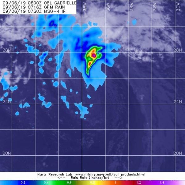
Image: The GPM core satellite passed over Post-Tropical Storm Gabrielle on Sept. 6 at 3:30 a.m. EDT (0730 UTC). GPM found the heaviest rainfall (purple) occurring nearly 200 miles north of the elongated center where it was falling at a rate of over 36 mm (about 1.4 inch) per hour. Areas of rainfall of about 25 mm (1 inch per hour) surrounded those stronger storms. (Credit: NASA/JAXA/NRL)


