
NASA has the unique capability of peering under the clouds in storms and measuring the rate in which rain is falling.
NASA has the unique capability of peering under the clouds in storms and measuring the rate in which rain is falling. Global Precipitation Measurement mission or GPM core satellite passed over Tropical Storm Jerry from its orbit in space and measured rainfall rates throughout the storm.
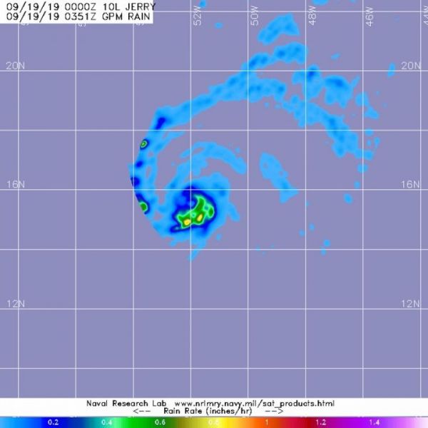
GPM passed over Tropical Storm Jerry in the Atlantic Ocean on Sept. 18 at 11:51 p.m. EDT (Sept. 19 at 0351 UTC). GPM found the heaviest rainfall stretching from the eastern to southern side of the storm where it was falling at a rate of over 25 mm (about 1 inch) per hour there and in a fragmented band of thunderstorms west of center. Forecasters at NOAA’s National Hurricane Center or NHC incorporate the rainfall data into their forecasts.
Hurricanes are the most powerful weather event on Earth. NASA’s expertise in space and scientific exploration contributes to essential services provided to the American people by other federal agencies, such as hurricane weather forecasting.
NHC issued a Tropical Storm Watch for Barbuda, Anguilla, St. Maarten, St. Martin, St. Barthelemy, Saba and St. Eustatius.
Read more at NASA/Goddard Space Flight Center
Image: The GPM core satellite passed over strengthening Tropical Storm Jerry in the central Atlantic Ocean on Sept. 18 at 11:51 p.m. EDT (Sept. 19 at 0351 UTC) and found the heaviest rainfall (orange) stretching from the eastern to southern side of the storm falling at a rate of over 25 mm (about 1 inch) per hour. (Credit: NASA/JAXA/NRL)


