
NASA-NOAA’s Suomi NPP satellite passed over the Caribbean Sea and used infrared light to obtain temperature information about Karen’s cloud tops.
NASA-NOAA’s Suomi NPP satellite passed over the Caribbean Sea and used infrared light to obtain temperature information about Karen’s cloud tops. Data showed powerful thunderstorms re-developed in around the storm’s center as it strengthened back into a tropical storm.
NASA-NOAA’s Suomi NPP satellite used infrared light to analyze the strength of storms within the structure of what was Tropical Depression Karen. Infrared data provides temperature information, and the strongest thunderstorms that reach high into the atmosphere have the coldest cloud top temperatures. This data is helpful to forecasters because storms are not uniform around tropical cyclones and it helps pinpoint where the strongest storms are located.
On Sept. 24 at 2:48 a.m. EDT (0648 UTC), the Visible Infrared Imaging Radiometer Suite (VIIRS) instrument aboard the Suomi NPP satellite found that the strongest thunderstorms around Karen’s center had cloud top temperatures as cold as minus 80 degrees Fahrenheit (minus 62.2 degrees Celsius) appearing in yellow. Those storms were surrounded by strong storms with cloud top temperatures as cold as minus 70 degrees Fahrenheit (minus 56.6 Celsius).
NASA research has shown that storms with cloud top temperatures as cold as or colder than minus 63 degrees Fahrenheit (minus 53 degrees Celsius) have the ability to produce heavy rainfall. Karen has a large area of storms around the center with temperatures colder than that threshold.
Read more at NASA/Goddard Space Flight Center
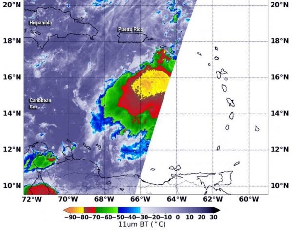
Image: NASA-NOAA's Suomi NPP satellite passed over Tropical Storm Karen and the VIIRS instrument aboard captured this image of the storm on Sept. 24 at 2:48 a.m. EDT (0648 UTC). Suomi NPP found that the strongest thunderstorms around the center had cloud top temperatures as cold as minus 80 degrees Fahrenheit (minus 62.2 degrees Celsius) appearing in yellow. Those storms were surrounded by strong storms with cloud top temperatures as cold as (red) minus 70 degrees Fahrenheit (minus 56.6 Celsius). (Credit: NASA/NOAA/NRL)


