
Tropical Storm Lorenzo continued to strengthen and appeared more organized on visible imagery from NASA-NOAA’s Suomi NPP satellite.
Tropical Storm Lorenzo continued to strengthen and appeared more organized on visible imagery from NASA-NOAA’s Suomi NPP satellite.
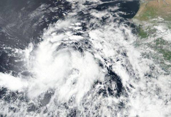
The shape of the storm is a clue to forecasters that a storm is either strengthening or weakening. If a storm takes on a more rounded shape it is getting more organized and strengthening. Conversely, if it becomes less rounded or elongated, it is a sign the storm is weakening.
On Sept. 24, the Visible Infrared Imaging Radiometer Suite (VIIRS) instrument aboard Suomi NPP provided a visible image of Lorenzo and showed it had become more organized over the previous 24 hours. The VIIRS image showed that many curved bands of thunderstorms have formed around the low-level center and there is a newly formed central dense overcast. A microwave image taken in the overnight hours showed that Lorenzo already had a very small central core.
Read more at NASA/Goddard Space Flight Center
Image: On Sept. 24, 2019, NASA-NOAA's Suomi NPP satellite passed over the eastern Atlantic Ocean and provided forecasters with this visible image of a more organized Tropical Storm Lorenzo. (Credit: NASA/NOAA/NRL)


