
Dropping cloud top temperatures from NASA-NOAA’s Suomi NPP satellite indicated Hurricane Lorenzo was getting stronger in the North Atlantic Ocean.
Dropping cloud top temperatures from NASA-NOAA’s Suomi NPP satellite indicated Hurricane Lorenzo was getting stronger in the North Atlantic Ocean.
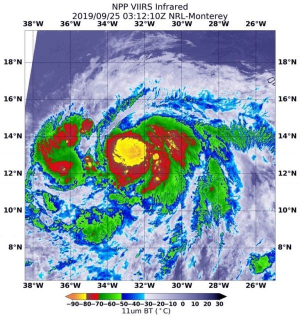
The Visible Infrared Imaging Radiometer Suite (VIIRS) instrument aboard Suomi NPP provided an infrared image of the storm. Infrared imagery reveals cloud top temperatures, and the higher the cloud top, the colder it is, and the stronger the storm. On Sept. 25 at 0312 UTC (Sept. 24 at 11:12 p.m. EDT) a large area of powerful thunderstorms circled the eye where cloud top temperatures were as cold as minus 121 Fahrenheit (minus 85 degrees Celsius). NOAA’s National Hurricane Center (NHC) forecasters cited that data in their Discussion at that time.
NASA research has shown that storms with cloud tops that cold have been found to generate heavy rainfall.
Read more at NASA / Goddard Space Flight Center
Image: NASA-NOAA’s Suomi NPP satellite passed over Hurricane Lorenzo in the North Atlantic Ocean and the VIIRS instrument aboard captured this image of the storm on Sept. 25 at 0312 UTC (Sept. 24 at 11:12 p.m. EDT). A large area (yellow) of powerful thunderstorms circled the eye where cloud top temperatures were as cold as minus 121 Fahrenheit (minus 85 degrees Celsius). Credit: NASA/NRL


