
New seafloor maps show for the first time the course of ancient ice masses. They show how they shaped essential habitat for the western Gulf of Alaska’s abundant fish, seabirds, and marine mammals.
New seafloor maps show for the first time the course of ancient ice masses. They show how they shaped essential habitat for the western Gulf of Alaska’s abundant fish, seabirds, and marine mammals.
Scientists wove together historical and modern data—from century-old hand-drawn charts to modern multibeam surveys. They created a highly detailed view of the seafloor and its geological features. The results will help scientists better understand the habitat requirements of many species and the oceanographic processes that influence their success.
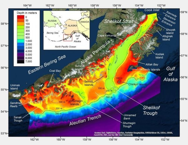
The western Gulf of Alaska is both ecologically and economically important. Shelikof Strait, a major feature of the region, holds special importance as spawning ground for the Gulf’s biggest stock of walleye pollock. Together with other Alaska pollock stocks, they are the target of the world’s largest fishery. Shelikof Strait is also home to rare species like the mysterious Pacific sleeper shark. Within the Gulf of Alaska bottom trawl survey area, almost half of all sleeper shark occurrences are in Shelikof Strait.
Despite its importance, until now much of the western Gulf of Alaska had not been mapped in sufficient detail to describe the geological features of this vital habitat. To create and analyze new maps, NOAA Fisheries and U.S. Geological Survey scientists teamed up to bring together geographical and geological expertise.
Continue reading at NOAA Fisheries.
Image via NOAA Fisheries.


