
NASA-NOAA’s Suomi NPP satellite passed over Mexico and found two small areas of very strong thunderstorms near two different coastlines.
NASA-NOAA’s Suomi NPP satellite passed over Mexico and found two small areas of very strong thunderstorms near two different coastlines. One area was in Potential Tropical Cyclone 17E in the Eastern Pacific Ocean and the other was for another system developing in the western Gulf of Mexico.
Potential Tropical Cyclone Seventeen-E developed around 11 p.m. EDT on Oct. 15 and by 11 a.m. EDT on Oct. 16, the center of circulation made landfall over the Mexican state of Oaxaca.
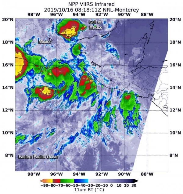
The Visible Infrared Imaging Radiometer Suite (VIIRS) instrument aboard Suomi NPP provided an infrared image of the storm. Infrared imagery reveals cloud top temperatures, and the higher the cloud top, the colder it is, and as such the stronger the storm. On Oct. 16 at 4:18 a.m. EDT (0818 UTC), an infrared VIIRS image showed two small areas around southern Mexico where cloud top temperatures were as cold as minus 80 degrees Fahrenheit (minus 62.2 Celsius). One area, located in the Eastern Pacific Ocean is associated with Potential Tropical Cyclone 17E. Both areas with strongest storms were over water. One in the Eastern Pacific and the other in the western Gulf of Mexico. Storms with cloud tops that cold have been found to generate heavy rainfall.
Read more at NASA/Goddard Space Flight Center
Image: NASA-NOAA's Suomi NPP satellite passed over Potential Tropical Cyclone 17E located along Mexico's west coast in the Eastern Pacific Ocean. Suomi NPP's VIIRS instrument captured this image of the storm on Oct. 16 at 4:18 a.m. EDT (0818 UTC). There were two small areas (yellow) within where cloud top temperatures were as cold as minus 80 degrees Fahrenheit (minus 62.2 Celsius). One over the Eastern Pacific and the other in the western Gulf of Mexico associated with another system. (Credit: NASA/NRL)


