
NASA’s Terra satellite passed over the Northwestern Pacific Ocean on Oct. 21 and captured a visible image of Tropical Storm Neoguri.
NASA’s Terra satellite passed over the Northwestern Pacific Ocean on Oct. 21 and captured a visible image of Tropical Storm Neoguri. Satellite imagery revealed that the storm is becoming extra-tropical.
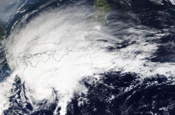
On Oct. 21, the Moderate Imaging Spectroradiometer or MODIS instrument that flies aboard NASA’s Terra satellite provided a visible image of Neoguri. The MODIS imagery indicated that Neoguri appeared elongated and large storm, where the bulk of clouds and convection (rising air that forms the thunderstorms that make up a tropical cyclone) were pushed to the northeast of the center as a result of southwesterly wind shear. Sheared convection and initial frontal features indicate that the system is undergoing extratropical transition.
What is Wind Shear?
In general, wind shear is a measure of how the speed and direction of winds change with altitude. Tropical cyclones are like rotating cylinders of winds. Each level needs to be stacked on top each other vertically in order for the storm to maintain strength or intensify. Wind shear occurs when winds at different levels of the atmosphere push against the rotating cylinder of winds, weakening the rotation by pushing it apart at different levels.
Read more at NASA/Goddard Space Flight Center
Image: On Oct. 21, 2019 the MODIS instrument that flies aboard NASA's Terra provided a visible image of Tropical Storm Neoguri along Japan's East coast. The storm was becoming extra-tropical. Credit: NASA Worldview, Earth Observing System Data and Information System (EOSDIS). (Credit: NASA Worldview, Earth Observing System Data and Information System (EOSDIS))


