
Tropical Storm Priscilla was short-lived because it formed on Sunday, Oct. 20 very close to the coast of western Mexico and made landfall that same day.
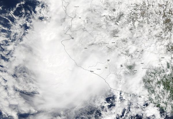
Tropical Storm Priscilla was short-lived because it formed on Sunday, Oct. 20 very close to the coast of western Mexico and made landfall that same day. NASA’s Terra satellite provided a visible picture of the storm as it was making landfall.
On Oct. 20, a Tropical Storm Warning was in effect for Punta San Telmo to Playa Perula as Tropical Storm Priscilla moved toward southwestern Mexico.
The National Hurricane Center noted on Sunday, Oct. 20 at 10 a.m. CDT, the center of Tropical Storm Priscilla was located off the west coast of Mexico about 65 miles (105 km) south-southeast of Manzanillo. It was moving toward the north near 7 mph (11 kph), and this motion is expected to continue through tonight. On the forecast track, the center of Priscilla will approach the southwestern coast of Mexico within the warning area later today, and move inland by tonight. Maximum sustained winds are near 40 mph (65 kph) with higher gusts. Tropical-storm-force winds extend outward up to 35 miles (55 km) from the center.
When NASA’s Terra satellite passed over western Mexico at 1:30 p.m. PDT (4:30 p.m. EDT), the Moderate Resolution Imaging Spectroradiometer provided a visible image. The image showed that Priscilla was already affected by its interaction with land and was somewhat elongated. The clouds associated with the tropical storm had spread out over Jalisco, Nayarit and Colima states.
Read more at NASA/Goddard Space Flight Center
Image: Tropical Storm Priscilla was short-lived because it formed on Sunday, Oct. 20 very close to the coast of western Mexico and made landfall that same day. NASA's Terra satellite provided a visible picture of the storm as it was making landfall. (Credit: NASA Worldview, Earth Observing System Data and Information System (EOSDIS)


