
Tropical Cyclone Kyarr is moving through the central Arabian Sea and NASA provided forecasters with an analysis of rainfall rates occurring in the powerful tropical cyclone.
Tropical Cyclone Kyarr is moving through the central Arabian Sea and NASA provided forecasters with an analysis of rainfall rates occurring in the powerful tropical cyclone.
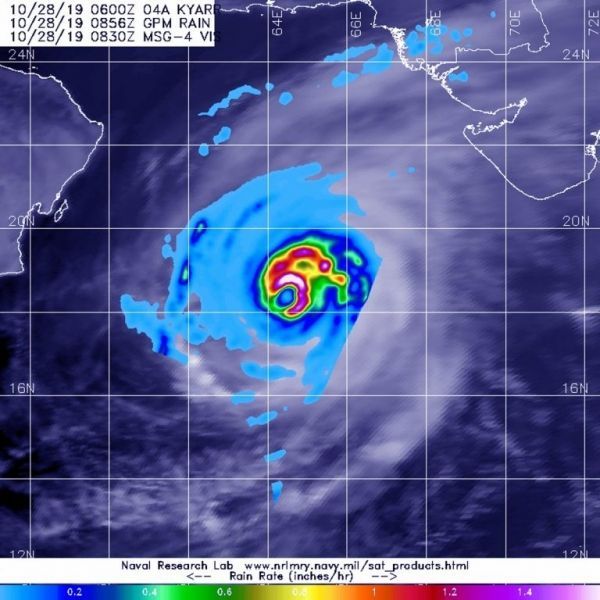
NASA has the unique capability of peering under the clouds in storms and measuring the rate in which rain is falling. Global Precipitation Measurement mission or GPM passed over Kyarr from its orbit in space and measured rainfall rates throughout the storm.
GPM passed over Tropical Cyclone Kyarr in the Arabian Sea, Northern Indian Ocean on Oct. 28 at 4:56 a.m. EDT (0856 UTC). GPM found the heaviest rainfall stretching from the northern to the eastern side of the storm where it was falling at a rate of over 40 mm (about 1.6 inches) per hour. Forecasters incorporate the rainfall data into their forecasts.
Read more at NASA / Goddard Space Flight Center
Image: The GPM’s core satellite passed over Tropical Cyclone Kyarr in the Arabian Sea, Northern Indian Ocean on Oct. 28 at 4:56 a.m. EDT (0856 UTC). GPM found the heaviest rainfall stretching from the northern to the eastern side of the storm where it was falling at a rate of over 40 mm (about 1.6 inches) per hour. Credit: NASA/JAXA/NRL


