
The latest addition to the Atlantic Ocean hurricane season developed quickly.
The latest addition to the Atlantic Ocean hurricane season developed quickly. NASA’s Aqua satellite passed over the eastern North Atlantic Ocean on Halloween and provided forecasters with an infrared view of Subtropical Storm Rebekah.
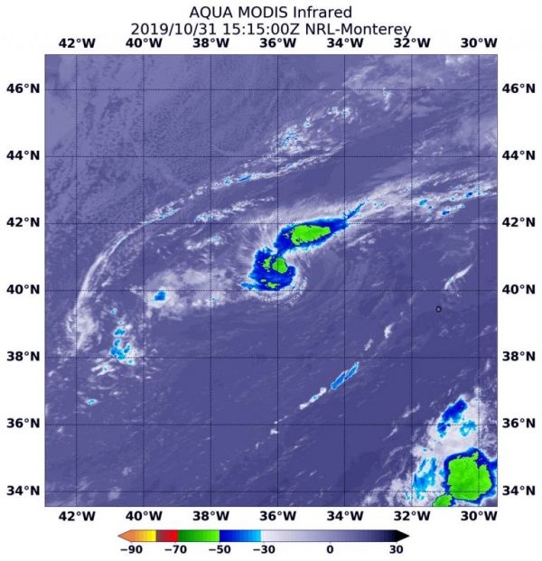
Infrared data provides temperature information, and the strongest thunderstorms that reach high into the atmosphere have the coldest cloud top temperatures.
NASA’s Aqua satellite passed over Rebekah on Oct. 31, 2019 at 11:15 a.m. EDT (1515 UTC) and measured the cloud top temperatures. The strongest storms with coldest cloud tops were as cold as or colder than minus 50 degrees Fahrenheit (minus 45.5 Celsius) around the center of circulation in a band of thunderstorms wrapping into the center from the northeastern quadrant.
What is a Subtropical Storm?
Rebekah developed on Halloween eve, Oct. 30, by 5 p.m. EDT as a subtropical storm. NOAA’s National Hurricane Center defines subtropical storms as “A non-frontal low-pressure system that has characteristics of both tropical and extratropical cyclones. Like tropical cyclones, they are non-frontal, synoptic-scale cyclones that originate over tropical or subtropical waters, and have a closed surface wind circulation about a well-defined center. In addition, they have organized moderate to deep convection, but lack a central dense overcast. Unlike tropical cyclones, subtropical cyclones derive a significant proportion of their energy from baroclinic sources, and are generally cold-core in the upper troposphere, often being associated with an upper-level low or trough. In comparison to tropical cyclones, these systems generally have a radius of maximum winds occurring relatively far from the center (usually greater than 60 nautical miles), and generally have a less symmetric wind field and distribution of convection.
Read more at NASA / Goddard Space Flight Center
Image: On Oct. 31, 2019 at 11:15 a.m. EDT (1515 UTC), NASA’s Aqua satellite revealed that Rebekah’s coldest cloud tops and strongest storms (yellow) were as cold as or colder than minus 50 degrees Fahrenheit (minus 45.5 Celsius) around the center of circulation in a band of thunderstorms wrapping into the center from the northeastern quadrant. Credit: NASA/NRL


