
The state of New South Wales (NSW) in south eastern Australia is continuing to experience devastating bushfires due to the dry tinder-like atmosphere in the territory: high winds, dry lightning and continuing heat.
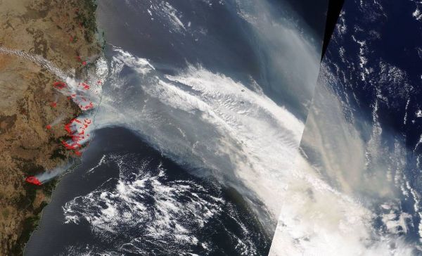
Approximately 69 fires are still raging in NSW according to its Facebook page and more than 70 are burning to the south in Queensland. And the summer has just begun in the region. NASA’s Terra satellite captured this image of the fires and the smoke pouring off the edge of Australia and into the southern Pacific Ocean on Nov. 13, 2019. Close to 1.1 million hectares (2.7 million acres) have burned since September.
In addition to the fires, which burned more than 200 structures in a new wave of fires that broke out Tuesday, they also brought another hazard – smoke. The fires are producing a fairly substantial amount of smoke. The smoke trail is so large it now spans the southern Pacific Ocean and has crossed the tip of South America into the Atlantic Ocean. A short animation from 8 Nov to 13 Nov of the NOAA- NASA Suomi NPP satellite’s OMPS instrument aerosol index shows the movement of the smoke and the resulting aerosols across the ocean. Note the two dates on each image, the left one refers to data west of the International Date Line, the right one refers to east of it.
NASA’s satellite instruments are often the first to detect wildfires burning in remote regions, and the locations of new fires are sent directly to land managers worldwide within hours of the satellite overpass. Together, NASA instruments detect actively burning fires, track the transport of smoke from fires, provide information for fire management, and map the extent of changes to ecosystems, based on the extent and severity of burn scars.
Continue reading at NASA Goddard Space Flight Center
Image via NASA Goddard Space Flight Center


