
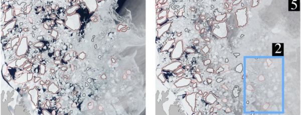
Image processing algorithms on satellite images show how sea ice drift affects freshwater flux in Arctic Ocean currents.
Climate change is accomplishing what centuries of exploration could not: opening the fabled Northwest Passage, a maritime shortcut from Europe to Asia via the Arctic Ocean.
Research led by the University of California, Riverside, could help ships navigating these freshly thawed routes avoid the Titanic’s fate with a new way to forecast the motion of floating ice.
A group led by Monica Martinez Wilhelmus, an assistant professor of mechanical engineering in the Marlan and Rosemary Bourns College of Engineering, is the first to use moderate resolution imaging spectroradiometer, or MODIS, satellite imagery to understand long-term ocean movements from sea ice dynamics.
MODIS sensors aboard NASA satellites have been collecting daily images of arctic ice floes — large, flat sheets of floating ice — for over 20 years, but using them to study how they move with ocean currents has been a laborious task. Clouds often obstruct the view and floes must be identified and marked by hand.
Continue reading at University of California Riverside
Image via University of California Riverside


