
NASA’s Terra satellite captured an image of Tropical Cyclone Ambali and the visible image showed that the storm was rapidly intensifying.
NASA’s Terra satellite captured an image of Tropical Cyclone Ambali and the visible image showed that the storm was rapidly intensifying.
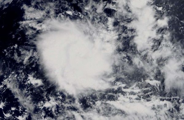
Ambali formed as a tropical depression in the Southern Indian Ocean on Dec. 4 and quickly strengthened into a tropical storm. Today, Dec. 5, it has reached what is considered hurricane status in the Atlantic and Northeast Pacific.
On Dec. 5, the Moderate Resolution Imaging Spectroradiometer or MODIS instrument that flies aboard NASA’s Terra satellite provided a visible image of Ambali. The MODIS image showed powerful thunderstorms circling the center of circulation. Meanwhile microwave satellite imagery shows tight banding of thunderstorms around the center of circulation and the development of an eye.
The shape of the storm is a clue to forecasters that a storm is either strengthening or weakening. If a storm takes on a more rounded shape it is getting more organized and strengthening. Conversely, if it becomes less rounded or elongated, it is a sign the storm is weakening. Ambali appeared more circular than it did 24 hours before, indicating it was strengthening and consolidating.
Read more at NASA/Goddard Space Flight Center
Image: On Dec. 5 2019, the MODIS instrument that flies aboard NASA’s Terra satellite provided a visible image of Tropical cyclone Ambali in the Southern Indian Ocean and showed powerful storms around the center of circulation and a large band of thunderstorms feeding into the center from the west. (Credit: NASA Worldview, Earth Observing System Data and Information System (EOSDIS))


