
Typhoon Phanfone, known locally in the Philippines as Ursula, was making landfall in the central part of the country when NASA-NOAA’s Suomi NPP satellite passed overhead on Dec. 24.
Typhoon Phanfone, known locally in the Philippines as Ursula, was making landfall in the central part of the country when NASA-NOAA’s Suomi NPP satellite passed overhead on Dec. 24.
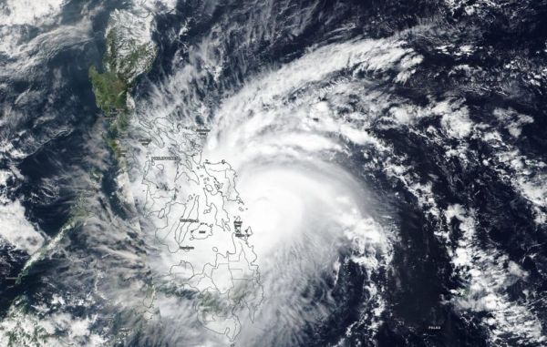
Suomi NPP’s VIIRS instrument provided a visible image of Phanfone that showed its center had made landfall in the eastern Visayas region of the Philippines. The Visible Infrared Imaging Radiometer Suite (VIIRS) is one of 5 instruments aboard Suomi NPP. VIIRS and other satellite imagery has shown an intermittent eye feature peeking out within a compact area of sustained deep central convection.
At 4 a.m. EST (0900 UTC) on Dec. 24, there were many warning signals in effect for the country. Philippines tropical cyclone Signal #3 was in effect for Luzon (northern Philippines) that included Masbate including Ticao Island. In Visayas (central Philippines), the warning covered Northern Samar, eastern Samar, Samar, Biliran, Leyte and extreme northern Cebu.
Read more at NASA / Goddard Space Flight Center
Image: NASA-NOAA Suomi NPP’s VIIRS instrument provided a visible image of Phanfone that showed its center had made landfall in the eastern Visayas region of the Philippines on Dec. 24, 2019. VIIRS and other satellite imagery has shown an intermittent eye feature peeking out within a compact area of sustained deep central convection. Credit: NOAA/NASA Worldview


