
Tropical Storm Claudia is battling wind shear as it continues moving away from Western Australia and through the Southern Indian Ocean.
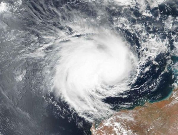
Tropical Storm Claudia is battling wind shear as it continues moving away from Western Australia and through the Southern Indian Ocean. NASA-NOAA’s Suomi NPP satellite provided forecasters with an image of the storm on January 13.
Visible imagery from NASA satellites help forecasters understand if a storm is organizing or weakening. The Visible Infrared Imaging Radiometer Suite (VIIRS) instrument aboard Suomi NPP provided a visible image of Claudia that showed the storm appeared elongated.
The shape of a tropical cyclone provides forecasters with an idea of its organization and strength, and NASA-NOAA’s Suomi NPP satellite provided a visible image of the landfall of the storm to forecasters. The storm appeared elongated from west to east. The imagery shows that Claudia is under strong vertical wind shear from the northwest to southeast. The low-level center now appears to the east of the main convection (rising air that creates the thunderstorms that make up the tropical cyclone).
Read more at NASA/Goddard Space Flight Center
Image: NASA-NOAA's Suomi NPP satellite provided forecasters with a visible image of Tropical Storm Claudia on Jan. 13 as it continued moving in a westerly direction in the Southern Indian Ocean. (Credit: NASA Worldview, Earth Observing System Data and Information System (EOSDIS))


