
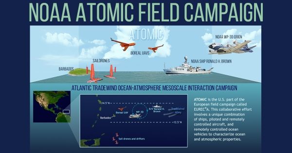
The project’s distributed sampling strategy is designed to help scientists better understand the transfer of heat, freshwater, and momentum between the atmosphere and the ocean.
Coordinated research missions by scientists from America, Europe and the island nation of Barbados are plying the tropical ocean off of Barbados in search of an answer to a pressing question: Will the fluffy, innocuous, postcard-worthy armadas of clouds that help cool this stretch of warm seas, and tropical seas the world over, survive climate change?
To date, science has investigated how these clouds form and dissolve primarily using theories, models, and also observations from satellites, sparsely-spaced buoys, and prior field campaigns. Similar to prior research studies, the American, European and Barbadian campaigns currently underway will be focused on obtaining new data from instruments carried on four research ships, five instrumented airplanes, research-quality ground stations, and targeted satellites.
But in a new tactic, they’re also deploying dozens of autonomous and remotely-piloted instrument platforms to capture simultaneous observations of the lower atmosphere and the upper ocean offshore of Barbados with unprecedented detail.
“We still have many questions about the spatial variability of these processes that aren’t captured by satellites, or intensive research studies conducted at a single location,” said Elizabeth Thompson, a scientist with NOAA’s Earth System Research Laboratory. “Our current weather models are tasked with representing the interactions of air, sea, and clouds across entire ocean basins - at the level of individual clouds and rain cells - but observations of these quickly evolving conditions aren't available at all those locations, not even close.”
Continue reading at NOAA Research
Image via NOAA Research


