
Warm air prevailed in the 2019-2020 winter season, preventing much ice from forming on the lakes.
Each winter, at least part of North America’s Great Lakes freeze. But whether it’s a boom or a bust year for ice cover comes down to air temperatures. This season, warmth has prevailed.
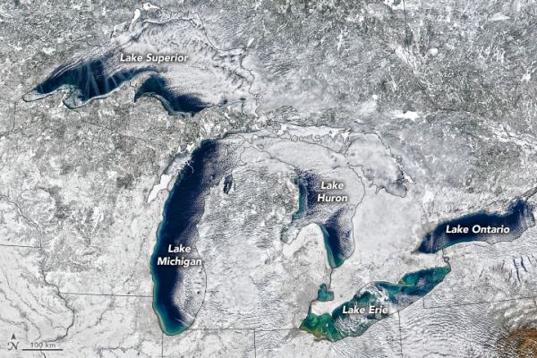
Blue-green open water was still widely visible on February 14, 2020, when the Visible Infrared Imaging Radiometer Suite (VIIRS) on the NOAA-NASA Suomi NPP satellite acquired the natural-color images above. Most of the white areas are snow and clouds, but a close look along parts of the shorelines—particularly Lake Superior—reveals small patches ice.
Ice that day spanned just 17 percent of all of the Great Lakes surface area combined. For context, ice usually spans 41 percent of the Great Lakes on an average February 14; it can be much higher or lower depending on the year. For example, early and persistent cold air temperatures during the winter of 2013-2014 brought record-high ice cover to most of the Great Lakes, reaching 88 percent coverage. The opposite scenario has played out in winter 2019-2020.
According to Jia Wang, an ice climatologist at NOAA’s Great Lakes Environmental Research Laboratory, four patterns of climate variability drive the warming or cooling effects on air temperature over the Great Lakes. So far this season, the North Atlantic Oscillation, the Atlantic Multidecadal Oscillation, and the Pacific Decadal Oscillation, have contributed to warm or very warm air over the Great Lakes. The El Niño-Southern Oscillation has been neutral (contributing cool air).
Continue reading at NASA Earth Observatory
Image via NASA Earth Observatory


