
As Tropical Cyclone Herold intensified, its eye appeared more defined in imagery taken by NASA’s Terra satellite.
As Tropical Cyclone Herold intensified, its eye appeared more defined in imagery taken by NASA’s Terra satellite.
A Tropical Cyclone Warning class 3 was in force for Rodrigues Island on March 17. Rodrigues is an autonomous outer island of the Republic of Mauritius in the Southern Indian Ocean. It is about 42 square miles (108 square kilometers). Rodrigues Island is located about 350 miles (560 kilometers) east of Mauritius.
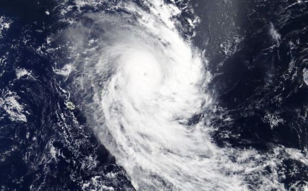
On March 17 at 5 a.m. EDT (0900 UTC), forecasters at the Joint Typhoon Warning Center (JTWC) noted “Infrared satellite imagery indicates a sharp intensification trend over the past 12 hours as the system formed an irregular 13-nautical mile wide eye.”
The Moderate Resolution Imaging Spectroradiometer or MODIS instrument that flies aboard NASA’s Terra satellite confirmed that intensification. MODIS provided forecasters with a visible image of Tropical Cyclone Herold that revealed a much clearer eye than on March 16. The eye was no longer obscured by high clouds, and the Terra view was able to see down to the ocean’s surface through the eye. Powerful bands of thunderstorms circled the eye.
Read more at NASA / Goddard Space Flight Center
Image: On March 17, the MODIS instrument that flies aboard NASA’s Terra satellite took this image of Tropical Cyclone Herold and showed a well-developed hurricane which is maintaining a clearer eye. Credit: NASA Worldview


