
NASA satellites have been providing forecasters with various types of imagery on Typhoon Amphan as it heads toward a landfall near the border of eastern India and Bangladesh on May 20.
NASA satellites have been providing forecasters with various types of imagery on Typhoon Amphan as it heads toward a landfall near the border of eastern India and Bangladesh on May 20.
NASA-NOAA’s Suomi NPP satellite provided visible imagery of Amphan and NASA’s Aqua satellite provided an infrared view of the storm’s cloud top temperatures. Amphan was moving north through the Bay of Bengal and forecast to make landfall in northeastern India near Kolkata, which is just west of the border with Bangladesh.
The Bay of Bengal is located in the northeastern part of the Indian Ocean. The Bay is framed by India to the west, Bangladesh to the north, and Myanmar to the east.
On May 19, the Visible Infrared Imaging Radiometer Suite (VIIRS) instrument aboard Suomi NPP provided a visible image Amphan. The image showed that Amphan covered the northern part of the Bay of Bengal.
Read more at NASA/Goddard Space Flight Center
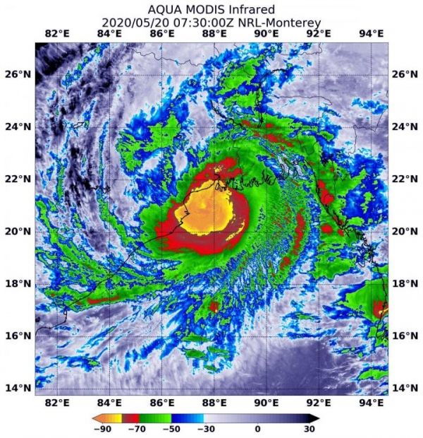
Image: On May 20, 2020 at 3:30 a.m. EDT (0730 UTC), the MODIS instrument that flies aboard NASA's Aqua satellite found coldest cloud top temperatures (yellow) in a large area around Amphan's center of circulation and along the coast on northeastern India. It was as cold as or colder than minus 80 degrees Fahrenheit (minus 62.2 Celsius). (Credit: NASA/NRL)


