
NASA’s Aqua satellite used infrared light to provide forecasters with a look at the temperatures of the cloud tops in Tropical Storm Mangga.
NASA’s Aqua satellite used infrared light to provide forecasters with a look at the temperatures of the cloud tops in Tropical Storm Mangga.
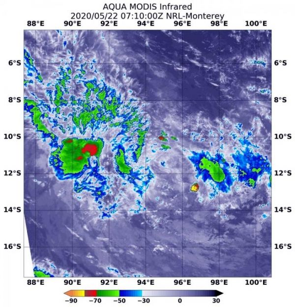
Mangga, formerly known as 27S, is moving through the Southern Indian Ocean. Mangga was approaching the Cocos (Keeling) Islands, where a tropical cyclone warning was in effect on May 22.
NASA’s Aqua satellite used infrared light to analyze the strength of storms in Mangga. Infrared data provides temperature information, and the strongest thunderstorms that reach high into the atmosphere have the coldest cloud top temperatures. On May 22 at 3:10 a.m. EST (0710 UTC), the Moderate Resolution Imaging Spectroradiometer or MODIS instrument aboard NASA’s Aqua satellite gathered temperature information about Tropical Storm Mangga’s cloud tops. MODIS found one area of powerful thunderstorms where temperatures were as cold as or colder than minus 70 degrees Fahrenheit (minus 56.6 Celsius). Cloud top temperatures that cold indicate strong storms with the potential to generate heavy rainfall.
Read more at NASA/Goddard Space Flight Center
Image: On May 22 at 3:10 a.m. EST (0710 UTC), the MODIS instrument aboard NASA's Aqua satellite gathered temperature information about Tropical Storm Mangga's cloud tops. MODIS found one small area of powerful thunderstorms (red) where temperatures were as cold as or colder than minus 70 degrees Fahrenheit (minus 56.6 Celsius). (Credit: NASA/NRL)


