
The western North Pacific Subtropical High (WNPSH) is a key atmospheric circulation system strongly influences weather and climate over the entire East and Southeast Asia.
The western North Pacific Subtropical High (WNPSH) is a key atmospheric circulation system strongly influences weather and climate over the entire East and Southeast Asia. It determines the strength and position of the Mei-yu/Baiu/Changma Front and the trajectories of typhoon and western Pacific tropical cyclones. How it will change in the future concerns the livelihood of many millions of people. The answer from state-of-the-art climate models is currently ambiguous. A total of 35 models participating in the Fifth Phase of Coupled Model Intercomparison Project (CMIP5) cannot agree on the sign of future changes.
A new research published in Nature Communications this week led by the Institute of Atmospheric Physics/Chinese Academy of Sciences (IAP/CAS), in collaboration with the Met Office Hadley Centre in the UK and Nanjing University, has found that such uncertainties are mainly resulted from systematic biases in simulating the historical sea surface temperature from individual models. With corrections using observed sea surface temperature, uncertainties can be reduced by 45%. Under the Representative Concentration Pathway (RCP) 8.5, a high greenhouse gas emission scenario, the models will tend to agree on a future intensification of the WNPSH, which implies stronger East Asian summer monsoon with increased rainfall but reduced typhoon landfalls over East Asia. In the meantime, it could also imply increased risk of heatwaves in the southern and eastern China.
"Uncertainties with climate models are there to stay, even models are been progressively improved. How to get the best information for climate adaptation and decision makers from currently available model projections is an important research topic." Said the lead author, Dr. CHEN Xiaolong from the Institute of Atmospheric Physics in Beijing. Dr. ZHOU Tianjun, executive director of the institute and a co-author, commented, "This is an important step forward in predicting potential future changes of the WNPSH and its impacts. The link with future changes of the East Asia summer monsoon and western Pacific tropical cyclones needs further investigation."
Read more at Institute of Atmospheric Physics, Chinese Academy of Sciences
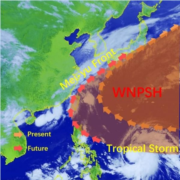
Image: A controlling circulation on location of Mei-yu Front and track of tropical storms. A new study reports that the western North Pacific Subtropical High will be intensified in future. (Credit: Xiaolong Chen)


