
NASA video looks at advances in hurricane forecasting, with a focus on the contributions from weather satellites.
The powerful hurricane that struck Galveston, Texas on September 8, 1900, killing an estimated 8,000 people and destroying more than 3,600 buildings, took the coastal city by surprise. This video looks at advances in hurricane forecasting in the 120 years since, with a focus on the contributions from weather satellites. This satellite technology has allowed us to track hurricanes – their location, movement and intensity.
“One of the dramatic impacts is that satellite data keeps an eye on the target," especially over unpopulated areas such as oceans, said JPSS Director Greg Mandt. “We’re sort of like your eyes in the sky to make sure that Mother Nature can never surprise you.”
A fleet of Earth-observing satellites, including those from the Joint Polar Satellite System (JPSS) and Geostationary Operational Environmental Satellite series (GOES-R), provides remarkable advances in hurricane forecasting. The JPSS polar-orbiting satellites measure the state of the atmosphere by taking precise measurements of sea surface temperatures and atmospheric temperature and moisture, which are critical to securing storm forecasts several days in advance.
Continue reading at NASA Goddard Space Flight Center
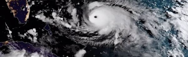
Image via NASA Goddard Space Flight Center


