
Researchers’ hybrid dataset includes satellite images, modeling and air samples.
It is not unusual to come across headlines about pollution or global warming and find that they reach different conclusions depending upon the data source.
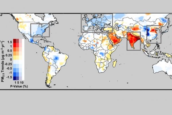
Researchers at Washington University in St. Louis used a harmonized approach, incorporating data from multiple satellites and ground monitors with computer modeling to compile a comprehensive, consistent map of pollution across the globe. Their data spans 1998-2018, providing a current picture of the state of the world’s air quality that reveals some surprises, both for better and for worse.
The research was led by Melanie Hammer, a postdoctoral research fellow in the lab of Randall Martin, professor of energy, environmental and chemical engineering in the McKelvey School of Engineering.
Results of their study that looked at PM2.5 — tiny particles that are able to make their way deep into a person’s respiratory system — were published June 3 in Environmental Science & Technology.
Continue reading at Washington University in St. Louis
Image via Washington University in St. Louis


