
Aerosol particles absorb and scatter incoming sunlight, which reduces visibility and increases the optical depth.
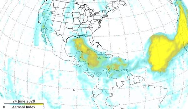
Dust storms from Africa’s Saharan Desert traveling across the Atlantic Ocean are nothing new, but the current dust storm has been quite expansive and NASA satellites have provided a look at the massive June plume. NASA-NOAA’s Suomi NPP satellite showed the blanket of dust had moved over the Gulf of Mexico and extended into Central America and over part of the eastern Pacific Ocean.
NASA uses satellites and other resources to track aerosol particles made of desert dust, smoke, and volcanic ash. The Visible Infrared Imaging Radiometer Suite (VIIRS) instrument aboard Suomi NPP provided a visible image while the Ozone Mapping and Profiling Suite (OMPS) Nadir-Mapper (NM) instrument aboard the Suomi-NPP satellite provided absorbing aerosol index values. The OMPS index indicates the presence of light absorbing aerosol particles (ultraviolet (UV)-absorbing particles in the air) such as desert dust. The absorbing aerosol index is related to both the thickness and height of the aerosol layer.
The Absorbing Aerosol Index is useful for identifying and tracking the long-range transport of volcanic ash from volcanic eruptions, smoke from wildfires or biomass burning events and dust from desert dust storms. These aerosol particals can even be tracked over clouds and areas covered by snow and ice.
Continue reading at NASA Goddard Space Flight Center
Image via NASA Goddard Space Flight Center


