
A low-pressure area strengthened quickly and became Tropical Storm Cristina in the Eastern Pacific Ocean and infrared imagery from NASA revealed the powerful thunderstorms fueling that intensification.
A low-pressure area strengthened quickly and became Tropical Storm Cristina in the Eastern Pacific Ocean and infrared imagery from NASA revealed the powerful thunderstorms fueling that intensification.
Cristina developed by 5 p.m. EDT on Monday, July 6, according to the National Hurricane Center in Miami, Fla. Six hours later it strengthened into a tropical storm and was renamed Cristina.
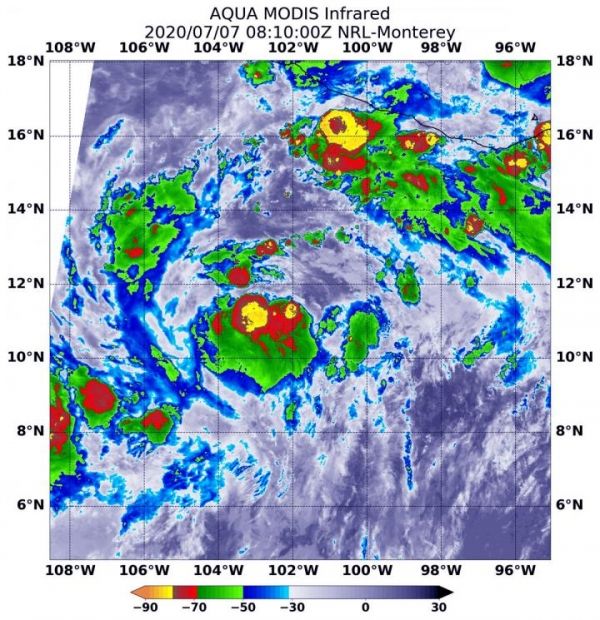
On July 7 at 4:10 a.m. EDT (0810 UTC), the Moderate Resolution Imaging Spectroradiometer or MODIS instrument that flies aboard NASA’s Aqua satellite used infrared light to analyze the strength of storms within Cristina. NASA researches these storms to determine how they rapidly intensify, develop and behave.
Tropical cyclones are made of up hundreds of thunderstorms, and infrared data can show where the strongest storms are located. That is because infrared data provides temperature information, and the strongest thunderstorms that reach highest into the atmosphere have the coldest cloud top temperatures.
Read more at NASA/Goddard Space Flight Center
Image: On July 7 at 4:10 a.m. EDT (0810 UTC) the MODIS instrument that flies aboard NASA's Aqua satellite revealed two areas of very powerful thunderstorms (yellow) around Cristina's center where cloud top temperatures were as cold as minus 80 degrees Fahrenheit (minus 62.2 Celsius). (Credit: NASA/NRL)


