
NASA’s Aqua satellite revealed better organization and colder cloud top temperatures in Tropical Storm Cristina, indications that the storm was strengthening.
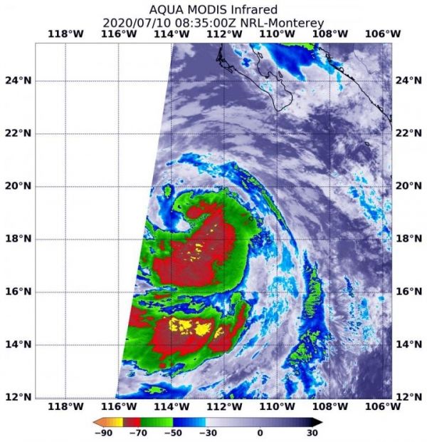
On July 10 at 4:35 a.m. EDT (0835 UTC), the MODIS instrument aboard NASA’s Aqua satellite analyzed Tropical Storm Cristina’s cloud tops in infrared light. Infrared data provides temperature information, and the strongest thunderstorms that reach high into the atmosphere have the coldest cloud top temperatures.
The Moderate Resolution Imaging Spectroradiometer or MODIS instrument aboard NASA’s Aqua satellite found that the most powerful thunderstorms were east and south of the center of circulation, where temperatures were as cold as or colder than minus 70 degrees Fahrenheit (minus 56.6 Celsius). These cloud top temperatures had become colder than they were over the previous day. Cloud top temperatures that cold indicate strong storms with the potential to generate heavy rainfall.
Read more at: NASA/Goddard Space Flight Center
On July 10 at 4:35 a.m. EDT (0835 UTC), the MODIS instrument aboard NASA's Aqua satellite gathered temperature information about Tropical Storm Cristina's cloud tops. MODIS found a small area of powerful thunderstorms (red) where temperatures were as cold as or colder than minus 70 degrees Fahrenheit (minus 56.6 Celsius). (Photo Credit: NASA/NRL)
NASA Infrared Data Shows Cristina Strengthening
Typography
- Font Size
- Default
- Reading Mode


