
NASA-NOAA’s Suomi NPP satellite passed over the Eastern Pacific Ocean and provided forecasters with a visible image of the waning Tropical Depression 7E.
NASA-NOAA’s Suomi NPP satellite passed over the Eastern Pacific Ocean and provided forecasters with a visible image of the waning Tropical Depression 7E. Wind shear and cooler waters were taking their toll on the storm.
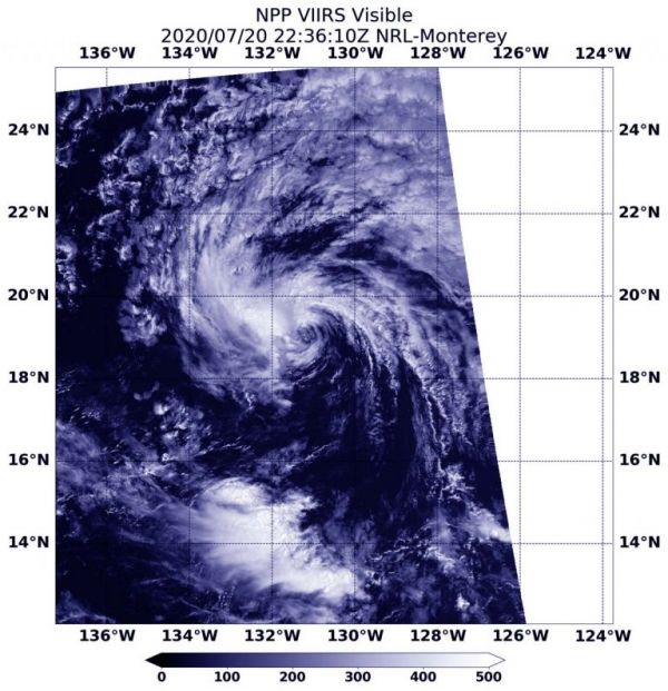
The Visible Infrared Imaging Radiometer Suite (VIIRS) instrument aboard Suomi NPP provided a visible image of the storm on Monday, July 20 at 6:36 p.m. EDT (2236 UTC) and revealed it was devoid of strong thunderstorms. The VIIRS image showed that the only deep convection associated with the depression was a small shapeless patch of clouds pushed about 70 miles to the west of the poorly defined surface center of circulation.
Vertical wind shear, that is, winds outside of a tropical cyclone at different heights in the atmosphere (the troposphere), pushes against a tropical cyclone and tears it apart. Tropical Depression 7E is being battered by easterly winds. The system is also moving over waters too cool to maintain strength. Tropical cyclones need sea surface temperatures of at least 26.6 degrees Celsius (80 degrees Fahrenheit) and 7E is moving through waters as cool as 24 to 25 degrees Celsius (75.2 to 77 degrees Fahrenheit).
Read more at NASA / Goddard Space Flight Center
Image: NASA-NOAA’s Suomi NPP satellite provided a visible image of Tropical Depression 7E on Monday, July 20 at 6:36 p.m. EDT (2236 UTC) and revealed it was devoid of strong thunderstorms and being affected by easterly wind shear. Credit: NASA Worldview, Earth Observing System Data and Information System (EOSDIS)


