
Former Hurricane Douglas has encountered strong wind shear after passing the Hawaiian Islands and has now weakened to a tropical storm.
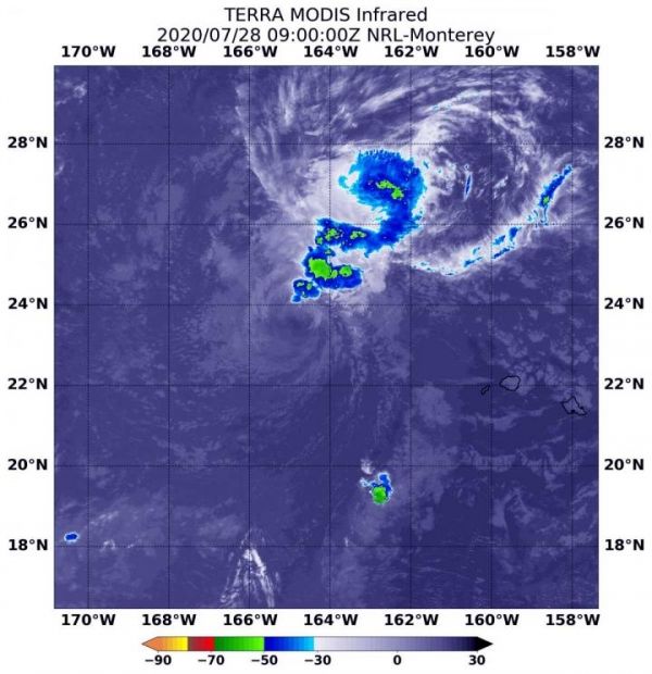
Former Hurricane Douglas has encountered strong wind shear after passing the Hawaiian Islands and has now weakened to a tropical storm. NASA’s Terra satellite provided infrared data to find that the strongest storms were displaced from the center as the storm weakens.
Warnings in Effect for Douglas on July 28
On July 28, NOAA’s Central Pacific Hurricane Center (CPHC) continued posting warnings and watches. A Tropical Storm Warning is in effect for portions of the Papahanaumokuakea Marine National Monument from Nihoa to French Frigate Shoals to Maro Reef. A Tropical Storm Watch is in effect for portions of the Papahanaumokuakea National Marine Monument from Maro Reef to Lisianski.
NASA’s Terra Satellite Reveals Effects of Wind Shear
NASA’s Terra satellite uses infrared light to analyze the strength of storms by providing temperature information about the system’s clouds. The strongest thunderstorms that reach high into the atmosphere have the coldest cloud top temperatures.
Read more at NASA/Goddard Space Flight Center
Image: On July 28 at 5 a.m. EDT (0900 UTC), the MODIS instrument that flies aboard NASA's Terra satellite gathered infrared data on Douglas that confirmed wind shear was adversely affecting the storm. Persistent south to southwest vertical wind shear showed strongest storms (yellow) pushed north and northeast of the center where cloud top temperatures are as cold as minus 50 degrees Fahrenheit (minus 45.5 Celsius). (Credit: NASA/NRL)


