
Tropical Storm Isaias has transitioned into a post-tropical storm as it moved out of the U.S. and into eastern Canada on Aug. 5 and 6.
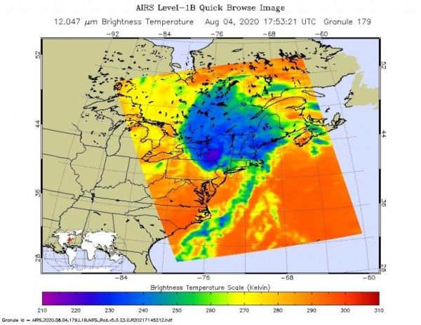
ASA created an animation of nighttime satellite imagery that shows Isaias’ track up the U.S. East Coast. In addition, NASA’s Aqua satellite provided a view of Isaias’ powerful storms over New York and New England.
What is a Post-Tropical Storm? A Post-Tropical Storm is a generic term for a former tropical cyclone that no longer possesses sufficient tropical characteristics to be considered a tropical cyclone. Former tropical cyclones that have become fully extratropical, subtropical, or remnant lows, make up three classes of post-tropical cyclones. In any case, they no longer possesses sufficient tropical characteristics to be considered a tropical cyclone. However, post-tropical cyclones can continue carrying heavy rains and high winds.
Infrared instruments enable satellites to gather imagery on storms at night because they read temperature. At NASA’s Goddard Space Flight Center in Greenbelt, Md. an animation of imagery from the VIIRS instrument aboard NASA-NOAA’s Suomi NPP satellite imagery showed the positions of Tropical Storm Isaias from Aug. 2 to Aug. 5 at night as it moved north along the U.S. East Coast.
Continue reading at NASA Goddard Space Flight Center
Image via NASA Goddard Space Flight Center


