
Tropical Storm Jangmi was exiting the East China Sea and moving toward the Sea of Japan when NASA’s Aqua satellite measured the strength of the system.
Tropical Storm Jangmi was exiting the East China Sea and moving toward the Sea of Japan when NASA’s Aqua satellite measured the strength of the system.
Jangmi formed as a depression on Aug. 8. At 5 a.m. EDT (0900 UTC), Tropical Depression 05W formed about 377 miles northeast of Manila, Philippines. Locally in the Philippines, the depression was known as Enteng. By 5 a.m. EDT (0900 UTC) on Aug. 9, the depression strengthened into a tropical storm.
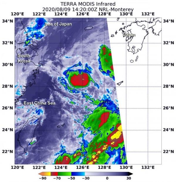
On Aug. 9 at 10:20 a.m. EDT (1420 UTC) infrared data from the Moderate Resolution Imaging Spectroradiometer or MODIS instrument that flies aboard NASA’s Aqua satellite provided a look at cloud top temperatures in Tropical Storm Jangmi as it was about to move out of the East China Sea. Strongest thunderstorms that reach high into the atmosphere have the coldest cloud top temperatures.
MODIS found the most powerful thunderstorms were around the center of circulation, where temperatures were as cold as or colder than minus 70 degrees Fahrenheit (minus 56.6 Celsius). Cloud top temperatures that cold indicate strong storms with the potential to generate heavy rainfall.
Read more at NASA/Goddard Space Flight Center
Image: On Aug. 9 at 10:20 a.m. EDT (1420 UTC) NASA's Aqua satellite gathered temperature information about Tropical Storm Jangmi's cloud tops. Aqua found the most powerful thunderstorms (red) around the center where cloud top temperatures were as cold as or colder than minus 70 degrees Fahrenheit (minus 56.6 Celsius). (Credit: NASA/NRL)


